
The watershed of southeastern Utah
September 11, 2009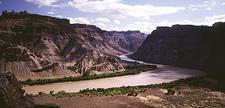
Southeastern Utah in Grand and San Juan Counties host four major rivers within its domain: Colorado, Green, Dolores and San Juan.
The Navajo Nation hosts the San Juan and Colorado Rivers.
Water resources of Grand and San Juan Counties.
GREEN RIVER
The states that make contributions to the mainstem of the Green River are: Wyoming, Colorado and Utah.
The Ute Indian Tribe hosts the Green River in Uintah County.
The uppermost reaches of the Green River begin in the state of Wyoming within the cradle of the Wyoming Range, and Wind River Range. The tallest peak in Wyoming is Gannett Peak (Wind River Range) at 13,804 feet.
Colorado's contribution to the Green River includes two major rivers: the Yampa and White.
The headwaters mountains of the Yampa are the Park and Rabbit Ears ranges. The tallest mountain is Grays Peak (Park Range) at 14,274 feet. The Yampa River joins the Green River at Dinosaur National Monument near the Utah/Colorado border.
Water Resources of Dinosaur National Monument.
The headwaters of the White River are the Flat Top Range. The White River joins the Green River near Ouray, Utah above Desolation Canyon.
Yampa River Basin Information. Colorado
Water Conservation Board.
White River Basin Information. Colorado Water Conservation Board.
The Duschene River is Utah's contribution to the Green, with headwaters in the Uinta Range. Kings Peak is the tallest peak of the Uintas at 13,528 feet.
Lower Duschene River wetlands recovery plan.
The Green River will touch Grand County on river left at Coal Creek Rapid (photo) in Gray Canyon. River right is Emery County.
The Green River enters San Juan County (river left only) and Canyonlands National Park below Mineral Bottom (photo). The river right side is Wayne County which hosts both Canyonland NP and Glen Canyon National Recreation Area.
Canyonlands Water Resources Report.
To be continued....
Talk about this article...